| Line 93: | Line 93: | ||
|20 |
|20 |
||
|[[National style roads|National style road]] |
|[[National style roads|National style road]] |
||
| + | |- |
||
| ⚫ | |||
| + | |1 |
||
| + | |20 |
||
| + | |10 |
||
| + | | |
||
| + | |- |
||
| ⚫ | |||
| + | |1 |
||
| + | |20 |
||
| + | |10 |
||
| + | | |
||
| + | |- |
||
| ⚫ | |||
| + | |1 |
||
| + | |20 |
||
| + | |10 |
||
| + | | |
||
| + | |- |
||
| ⚫ | |||
| + | |1 |
||
| + | |20 |
||
| + | |10 |
||
| + | | |
||
|} |
|} |
||
| − | |||
| ⚫ | |||
| ⚫ | |||
| ⚫ | |||
| ⚫ | |||
==='''Fast Lanes (Highways)'''=== |
==='''Fast Lanes (Highways)'''=== |
||
Revision as of 01:55, 26 October 2011
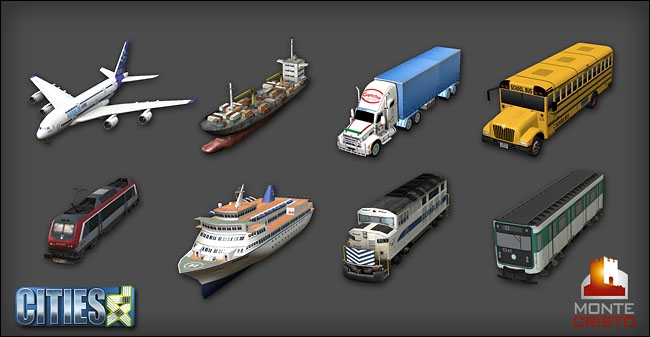
Various methods of transportation.
Transportation is an area that Monte Cristo was taking very seriously in the development of Cities XL. As the picture on the right shows, there were plans for quite a number of transportation methods in the game, and each one was to be developed beyond the mere drawing a line and building stations along it. Unfortunately, it proved really difficult to do all in time for the game's release, and there was also the idea of gradually developing more and more transportation methods in time, thanks to the Planet Offer's additional income. So, at the time of the release of Cities XL, there were only three principal transportation methods, conventional roads, harbors (sea transport) and airports. Of these, the former was used for both in-city and inter city transport, while the later were dedicated inter-city.
Couple of months later, the first in-city mass transport mode, Busses, was introduced, and another one, Metro, came later with the release of Cities XL 2011. However, both are developed far beyond anything we've seen so far in a city-building game.
There is Train transport coded in the game, with models of tracks, bridges and even a train station. The trains are intended as inter-city transport, alternative to Road City links and the Harbors and Airports as sources of Freight/Passenger services. However, the system is not active at present.
Types Of Transportation
Transportation in cities XL is broken down into 5 main categories: Roads (the main road network which gives buildings transport access), Fast Lanes (dedicated expressways for wheel-based vehicles), Bridges/Tunnels (including all different modles for the different widhts of roads + Fast lanes), In-City Mass Transport (Busses, Metro) and Inter-City Mass Transport (Harbors, Airports, Rail).
Roads
This is the main in-city and inter-city means of transport. Roads need to be connected to almost all buildings for them to function (very few exceptions). In the city, the road system not only allows people to get places in their cars, but also serves as service distribution channel, that is, the converage of services 'spreads' along the road network in a certain radius. Outside your city, roads can serve as freight and passenger distributors via City links , which can be established along the map's borders. Note that City links can only be opened in certain areas (shown on the respective Resource layer), and each one 'eats up' a part of that area, so that eventually you won't be able to build any more City links.
Road building system
The way you build roads in Cities XL is nothing short of amazing. This is one of the aspects Monte Cristo payed the most attention to, and the results are great indeed. First of all, the maps are inherently grid-free, which means that you can build in any direction that takes your fancy, and you're not constrained by anything but the naturall features of the land . The engine allows you to build almost any kind of road you could think of, using any shapes you could invent. And more: after you build a road, you can click on any stretch of it and use upgrade options to change many apects of the road, such as number of lanes, direction of lanes, or sometimes even the type of the road. The one thing you can't change is the width of the road.
When you start building a road, or any transportation network for that matter, you'll first draw a 'blueprint' of the road. Every time you left-click you'll create points that fix the blueprint to this location and act as possible direction changers. The blueprint will be green if everything's OK, and will turn red if there's a problem hindering construction (you'll also see small icons at the problematic points that give you an idea of the nature of the problem, like 'slop too steep', or 'not enough space for the road'). To complete the road and place it permanently, click again over the last point you've created.
You have three main tools at your disposal:
- Straight tool - it builds straight sections from point to point; it won't snap to any grid or direction, but when you're building into one of the 8 main compass directions in relation to the last point, the road blueprint will turn blue (otherwise it's gonna be either green or red)
- 8-orientations tool - this one will snap to an invisible grid in one of 8 directions in relation to the last point, eliminating the annoying for some people grid-free map. Handy if you're a fan of planned grid cities.
- Curved tool - the big inovation of the system, it allows you to build curves, instead of straight lines. Use the points to fix the angle of the curve, and/or change direction.
Note that you can't use a mix of the three tools - while you're still 'planning' the road, you can change freely which tool you're using, but changing the tool will also change the blueprint you've drawn so far. However, you can build the road step by step, changing the tools for after completion each step. Planning ahead and using fantasy you will be able to create almost any network you could think of.
Going around existing structures.
When you wanna trace a road right next to existing structures/fields, you'll have some problems, mainly due to the grid-free system. You want, of course, to place the road adjacent to the existing stuff, not too far away, and this is especially an issue when you're replacing old roads with larger ones. However, the game will tell you there's no space for this road, and it'll always look like the road is just too big. Calm down, and do the following: click on the desired road, select either the straight tool (works better usually) or the curved one, then hover right next to one of the existing buildings (the red entry point would do well) - the mouse pointer will snap automatically at the correct distance for the new road. Click to start drawing, then little by little trace the road, first to the edge of this building, then to the edge of the next one, etc. The engine will usually snap the roads to the buildings, unless you're doing something wrong. The straight tool and moving slowly shoud do the trick. When you've almost reached the road where you're gonna connect (like the last building before the crossroad), click and confirm the road.
The problem comes, however, when you try to join the new road to an old one, and there's a building at the corner. Currently, the engine just tries to center the two roads, and the new one inevitably runs into the corner building, ignoring the space on the other side. The only possible solution (for now, until MC decide to improve the junctions handling) is to destroy the building at the corner. That's why I told you earlier to confirm the road BEFORE you try to reach the crossroad. If you didn't there's no way to finish, and you'll lose all the carfull tracing you've done so far.
Crossing roads (junctions)
Because of the grid-free system crossroads are much more varied in Cities XL. You can have them in almost any shape and you can join as many roads as there is space. The only constraint is a minimum angle.
Unfortunately, it is impossible to merge roads, without causing a traffic light to appear. So, we're not yet able to join a small road to a large avenue, where the road simply melts in the avenue without stopping the traffic, the way a ramp would join a highway.
We have Roundabouts, however, which allow joining roads without stopping traffic. Currently, they are set pieces which connect only to a limited range of roads, but we might expect more varieties in the future.
Lanes management.
Here comes the micromanagement fun: almost every road, excluding expressways and highways, can have its lanes adjusted. To do that just click on the road - a panel will open with upgrade options. Warning, you'll be selecting only a secion of the road (from one crossroad to the next one), so you have to make the adjustments segment by segment. Depending on the road type, you'll have:
- two lanes one way (or the other), for small and simple roads
- four lanes one way (for avenues)
- four lanes one way with trees (for large avenues). This maintains the trees.
- two lanes one way, three lanes the other way (for large avenues). This excludes the trees.
- five lanes one-way (for large avenues). Also excludes trees.
NOTE: Cities XL doesn't allow you to increase the width of a road by a simple click. If you need to build a larger road over a smaller one, you'll need to manually destroy the old road, and replace it with the new one.
With these adjustments you can really direct the traffic flow in the city. If your downtown area is suffering, make two paralel avenues one way!
It's also a good alternative to the expressway to built two large avenues next to each other, and turn each one one-way.
Road types
All of the types of roads are freely interconnectable, i.e. you can make intersections with each one of them, and also freely convert one into another.
| Type | Maintenance Cost (C) | Capacity (cars/min) | Width (m) | Notes |
|---|---|---|---|---|
| Small Farm Road | 1 | 10 | 10 | dirt road |
| Medium Farm Road | 1 | 10 | 15 | dirt road |
| Small Road | 1 | 20 | 10 | |
| Simple Road | 2 | 40 | 15 | |
| Simple Grassy Road | 2 | 40 | 20 | National style road |
| Small Avenue | 1 | 20 | 10 | |
| Large Avenue | 1 | 20 | 10 | |
| Large Luxurious Avenue | 1 | 20 | 10 | |
| Expressway | 1 | 20 | 10 |
Fast Lanes (Highways)
This is currently the largest and fastest road, 8 lanes, 320 cars/min. It is basically a fenced road corridor, and it has its own rules:
- You can't make normal intersections with it, because other roads can't cross with it on the same level. You need to either use one of the set pieces to connect it to the rest of the road network, or you need to build bridges/tunnels to go over/under it.
- Highways don't provide your buildings with road access! That means that if you build something adjacent to a highway, the building will have the 'Not connected to the City Hall' icon and won't function. So, you must provide an alternative, normal road access to buildings close to a highway.
- You can only draw highways with the curved tool for some reason. Here are the set pieces part of the highway system:
- Clover Shaped Interchange
- Road Interchange
- Simple Interchange
- Large Interchange
- Very Large Interchange
- Highway
Bridges and tunnels
Building bridges and tunnels is combined in Cities XL with the very elegant solution of adding a 3d dimension (elevation) to the normal road building tools. After you select from the menu the type of bridge you want to build you will start drawing a blueprint, using the Stragith and Curved tools. The trick is that now you can also control the height of the construction by pressing Shift and moving the mouse up or down to raise or sink the blueprint. In this way you can elevate the road above ground level and create a bridge, or sink it bellow ground level and create a tunnel.
The mouse has an additional line above or bellow the point to show current elevation in relation to ground level, and allowing you to have an idea where exactly you are. The points you create here serve not only as direction changers, but also as elevation changers. Of course, there are some tricks and you'll need some time for experimenting in order to figure out the limitations of the system. There are minimum height requirements for passing over other roads, or buildings, and minimum depth requirements for passing under them. Be patient! To complete the bridge/tunnel, you can either terminate it in the normal way (just be carefull not to leave the end some 10 meters above ground) , or alternatively to connect it succesfully to an existing road.
Types of bridges:
- Highway Bridge
- Expressway Bridge
- Large Avenue Metal Bridge
- Large Avenue Bridge
- Small Avenue Bridge
- Simple Road Metal Bridge
- Simple Road Bridge
- Small Road Bridge
In City
This is the Mass Transport system providing your citizens with alternatives to cars for going to work and back. The two options currently available are described at lenght in their respective sections:
Inter City
This includes the transport options for connecting your city to the other ciies on the Planet. They provide you with additional City Link options, and expand your Freight and Passenger trading capacity. The options include Sea transport (Harbors) and Air Transport (Airports), with the first dedicated to freight, and the second - to Passengers.
There is a third option coded in the game - Rail transport, which will include freight and passenger trains for Inter-City connections. Unfortunately, MC never got around to releasing trains, and neither did Focus, at least until now. Still, this is a much anticipated development which will undoubtedly appear in the game sooner or later.
- Harbor (Large)
- Harbor (Small)
- Large Airport
- Small Airport
- Trains
- Others TBA???
Confirmed transportation
The Forms of Transportation Confirmed for Cities XL (Released or not) are: